
Subscribe
Alert Me when new Data Products are available


↓ Features
↓ Variables
↓ Geography
↓ Methodology
CensusCD 1990 Long Form in 2010 Boundaries allows users to access US Census data from 1990 and easily compare it with the 2010 Census data. It is the finest source of Census data from 1990 expressed at all of the 2010 ACS geographies. The CensusCD 1990 Long Form in 2010 Boundaries is based upon the long form (STF 3): questions answered by one in six households in the 1990 census. It includes detailed demographic data about topics such as population, household structure, income, poverty, education level, employment, housing costs, immigration, and other variables. The 1990 Long Form in 2000 Boundaries is an invaluable resource for policy makers, community organizations, and researchers who want to analyze the changes that have occurred in the U.S. from 1990 to 2010.
Geographic boundaries change from census to census based on many factors. In the example below Williamson County, Texas is shown broken-out at the census tract level. At a glance, one can observe that there are changes in the census tracts from 1990 to 2010. In fact, Williamson County split tracts into multiple parts, with the overall number of tracts growing from 64 to 89 tracts.
| 1990 Williamson County, TX Total Census Tracts (64) 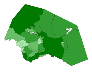 |
2010 Williamson County, TX Total Census Tracts (89) 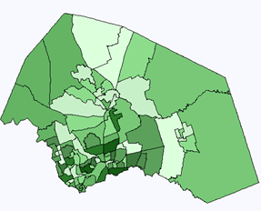 |
Taking a closer look at Pima County from 1990 to 2000 reveals the modifications in tract boundaries that significantly impact how researchers study and account for changes in a population over time. For example, below is a single 1990 Tract # 020898 that was broken into 7 tracts in the 2010 Census. It is a straight forward 1 to 7 correspondence.
| Williamson County, Texas | |
1990 Tract Boundary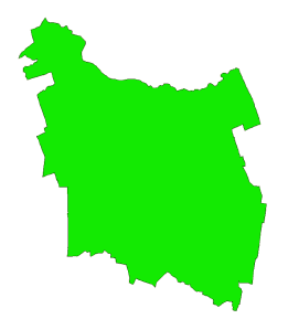 |
2010 Census Tract Boundaries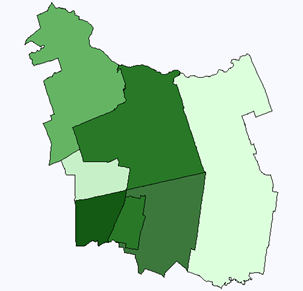 |
However, the changing tract boundaries from 1990 to 2010 are not always that straight forward. In the next example from Williamson County, there are three tracts, # 020101, 020102 & 020200, which change into 11 new tracts in 2010. The correspondence in this case is 3 to 11. From these two examples in Williamson County, it becomes evident why it is so difficult for researchers to contend with the issue of changing geographic boundaries over time.
1990 Tract ID# 004024 & 004028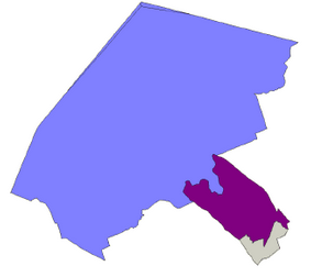 |
2000 Census Tract Boundaries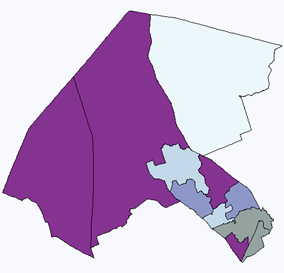 |
Normalizing the Data
The actual re-mapping procedure for converting data from 1990 to 2010 boundaries is quite complicated. Here is a link for those wishing a more technical explanation of this task (click here). The basic procedure was to use the TIGER/Line 2010 relationship between 2010 blocks with those from 2000 and then from 2000 to those in 1990. This allowed us to identify how block boundaries had changed between censuses. For example, if a 1990 block split into two for the 2000 census, others tracts merged, while some tracts both merged and then split. The table below shows the three scenarios (many to one, one to many, and many to many).
There are over 11 million blocks in the US in 2010, so in fact these are very small geographic areas. But in order to be more precise, when necessary we broke blocks down. When the blocks split then the matter of how to split the population becomes a problem. (When they merge you just add the numbers). In order to determine how to subdivide blocks we looked at the TIGER Street files. The assumption being that people live on or near streets, so the number of addresses on a street will indicate the approximate weight to give to that area of the block.
From the blocks or block parts we created a Block Weighting File. These population weights were then applied to the various other counts to convert them from 1990 to 2000 and then from 2000 to 2010 block boundaries. Once the data had been calculated at the block level we were then able to sum up the blocks to the various other geographies. Testing was then done to assure the accuracy and validity of the weighting method compared with the original numbers from the 1990 Long Form data set.
| Basic | |
|---|---|
| State User | $449.00 |
| National User | $895.00 |
| STF3A Demographic Data | ● 3770 variables |
Census 1990 in 2010 Boundaries includes over 3,500 demographic variables from 1990 that are cross-walked to the 2010 geographies. They include such variables as total population, median income, housing values, or even the percent of houses with indoor plumbing. The basis for these demographics is the 1990 Census STF-3 files.
Census 1990 in 2010 Boundaries covers over 300,000 locations from 2010 (zips, block groups, tracts, counties, etc). In 1990 the Census Bureau organized the variables into 300 different Tables. To aid with selection, we categorized the tables into the following 14 groups:
General - summaries of demographic characteristics
Header - Geographic Identifiers, details of geographic definitions
Person - population variables by age and gender
Families - characteristics of family units
Household - descriptions of family and non-family living
Race - racial data by age and gender
Language - first and second languages and English proficiency by ages
Occupation - profession, employment, and commuting times
Education - educational enrollment and attainment levels by age and gender
Income - income source and amounts by household, family, per capita also broken out by age and race
Poverty - levels of poverty by household, age and race
Housing - size, value, plumbing and kitchen facilities, heating fuels
Rent Housing - rental amounts and characteristics
Owner Occupied - owner characteristics, mortgage amounts, and housing values
For a complete list of 1990 Long Form variables, Click Here.
12 geographies covering over 360,000 locations
Census 1990 in 2010 Boundaries gives you access to over 3,500 demographic variables for 11 different geographies. These geograhic areas consist of the following levels (numbers indicate how many specific areas are within that geographic level):
United States (1)
States (51)
Combined Statistical Area (CSA) (160)
Metropolitan Statistical Area (MSA) (1,013)
111th Congessional District (423)
American Indian Reservations (406)
Counties (3,143)
Census Designated Places (29,261)
Zip Codes (ZCTA) (31,810)
Census Tracts (73,057)
Block Groups (217,740)
Methodology coming soon, we are still developing the exact weighting parameters.
