
Subscribe
Alert Me when new Data Products are available


↓ Features
↓ Variables
↓ Geography
↓ Mapping
↓ Advanced Options
The GeocodingDVD matches your addresses to latitude/longitude coordinates and then adds census geographic designations to those coordinates including historic census codes. Geocoding can be done for an individual address (manual mode) or a list of thousands or millions of addresses (batch mode). The latest version uses the 2015 TIGER/Line ® Shapefiles for enhanced geocoding and has improved address matching over previous versions.
The GeocodingDVD also appends the Zip+4s to the matched address, as well as adding historic Census 1970, 1980, 1990, and 2000 Tract and Block Group FIPS codes. Our geocoder always gives you the option of appending demographic data to your address for easy customer profiling, see details below.
The GeocodingDVD offers superbly accurate address matching because it geocodes to the street segment level. It has the coordinates (latitude/longitude) for every section of every street so that it can pinpoint an address with extreme precision. It then translates the latitude/longitude to the Census Block centroid so that data can be added even at this very granular level.
The latest version of the GeocodingDVD automatically generates a map layer within our Map Viewer that will create points on the map as well as allow you to overlay the streets or block group boundaries over the map. You can also create an ArcGIS shapefile for importing into your mapping software. Our latest online version uses Google ® maps that also show the block group boundaries of the surrounding areas.
The standard GeocodingDVD appends demographics from the latest American Community Survey (ACS) 5-Year Estimates data file. There are nearly 100 demographic variables including population, race, housing counts, income, education, etc.
The Professional GeocodingDVD with Current Estimates and 5-Year Projections appends additional demographic variables from the current Estimates and 5-Year Projections. It includes a comprehensive set of variables including population counts, age, race, households, income, and housing.
Users can also append thousands of additional variables from our other Census products. For example, you can append more detailed demographic data from the Census 2000 Long Form, or data from other historic censuses such as 1980 and 1990 from our normalized data products. The GeocodingDVD adds tract, block group, and block codes that can be easily matched to exported data from our other demographic data products.
Demographic variables are from the latest American Community Survey (ACS) 5-year estimates data file.
| Basic | Professional | |
|---|---|---|
| State User - 1 million addresses | $595.00 | $845.00 |
| State User - 2 million addresses | $893.00 | $1,268.00 |
| State User - 5 million addresses | $1,190.00 | $1,690.00 |
| State User - 10 million addresses | $1,785.00 | $2,535.00 |
| State User - 20 million addresses | $2,380.00 | $3,380.00 |
| State User - Unlimited addresses | $2,975.00 | $4,225.00 |
| State User - Annual Renewal | Custom | Custom |
| National User - 1 million addresses | $1,195.00 | $1,595.00 |
| National User - 2 million addresses | $1,793.00 | $2,393.00 |
| National User - 5 million addresses | $2,390.00 | $3,190.00 |
| National User - 10 million addresses | $3,585.00 | $4,785.00 |
| National User - 20 million addresses | $4,780.00 | $6,380.00 |
| National User - Unlimited addresses | $5,975.00 | $7,975.00 |
| National User - Annual Renewal | Custom | Custom |
| Demographic variables | ✪ 99 variables | ✪ 99 variables |
| Additional demographic variables | ✪ 162 variables |
Our Geocoder will append the following Geographic Identifiers:
Using the Census 2010 Block FIPS code, the following can be derived:
A Census Block FIPS code has 15 digits and is structured as follows:
AABBBCCCCCCDEEE
So if you want the Block Group Code it would be the first 12 digits (AABBBCCCCCCD)
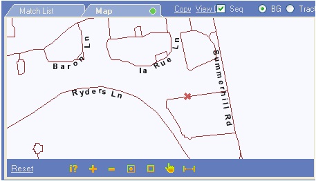
Results of manual geo-coding are displayed as street maps. The geo-coded position is displayed as a small red "X". You can zoom in or zoom out for more detail or more of an overview of the area.
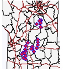
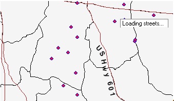
Result of batch geo-coding are displayed as point maps with optional street and Census Block Group background maps.
This is a map of geocoded addresses with block group boundaries overlayed in black and large streets in brown
As you zoom in you can see first the major highways and then if you continue to zoom in you will see the local streets.
Fuzzy Logic to clean your file and maximize your "hit" rate.
For example if you allow place-based zip code match then if the address is not found in a given zip code (let’s say 2 numbers are transposed so instead of 08816 you have 08861) or if there is just a typo and it is 00816. The address will fail. But allowing for place-based zip code matching means that the geocoder will search all zip codes associated with East Brunswick NJ (in this example) and would then be able to locate your address and correct the zip code.
Here are the fuzzy logic options available:
| Option | What the logic allows |
| Allow phonetic match of state name | The full state name in an address (but not an abbreviation) will be matched phonetically |
| Allow place-based zip code match | If a street is not found in a zip, you can allow scanning other zips associated with the place |
| Allow phonetic match of street name | The geocoder will use phonetic matching for street names |
| Disregard house number parity | Normally the geocoder matches even/odd addresses with even/odd address ranges. You can specify to disregard this practice |
| Allow closest address match | Finds the closest address range to match the house number (rather than an accurate one) |
| Allow fuzzy street type match | For example, your list has avenue and it will geocode with road or street |
| Geocode no matter what | Geocoder will always use the closest (rather than accurate) match |
Offset coordinates to street side
Alters the longitude and latitude coordinates to be offset by the specified number of feet or meters according to the street side at which the address has been found. The default is 30 – since we know that houses are not in fact sitting on the edge of the road but usually are back a distance covered by the front lawn.
Clean address list
If checked, a xxx_clean_nnn.txt file with syntactically correct addresses is created.
Load area map
If checked, you can view a map of your points with the block group boundaries superimposed over them.
Load street map
If checked, you can view a map of your points with the streets superimposed over them – they will not be labeled until you zoom in sufficiently to read them.
Accuracy codes (ACC_CODE, ACCURACY, description):
0, "aExc", "Exact Match"
1, "aIpl", "Linear Interpolation"
2, "aZip", "Zip Code Mismatch"
4, "aCnm", "City Name Mismatch"
8, "aPar", "Parity Mismatch"
16, "aSDm", "Street Direction Mismatch"
32, "aCAd", "Closest Address"
64, "aStr", "Street Centroid"
128, "aSTm", "Street Type Mismatch"
256, "aFSN", "Fuzzy Street Name"
512, "aFCN", "Fuzzy City Name"
1024, "aZiC", "Zip Centroid"
2048, "aStC", "State Centroid"
4096, "aUSC", "U.S. Centroid"
Error Codes (ERR_CODE, ERROR, description):
0, "", ""
1, "ePrs", "Address parsing error."
2, "eAnf", "Address not found."
3, "ePnf", "Point not found."
4, "eCvg", "Address is out of coverage."
5, "eExr", "License is expired."
6, "eRec", "Record limit is exceeded."
7, "eUnk", "Unexpected error occured."
Database codes (SRC_CODE, SOURCE, description):
1, "TIGER", "TIGER/Line"
2, "NAD", "National Address Database"
4, "OPEN", "OpenAddresses"
8, "OSM", "OpenStreetMap"
16, "USPS", "United States Postal Service"
